Stuif's Adventures
| Ulu Gepai 28/3/2010 | ||||||||||||||||||||||||||||||
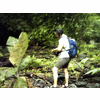
| Last year I have published a Multiply report about the Tigok waterfall, discovered by my friend Siang Hui, using Google Earth. Exploring the high-res Google Earth imagery of the region east of Bidor, he had spotted other waterfalls in the upper regions of the Gepai river. The Gepai waterfall , near to Bidor is a popular destination for the locals. Would it be possible to reach the (faraway!) upstream falls, starting from here? According to Siang Hui, access should be possible from Kg Senta, an Orang Asli kampung on the way to the Tigok Fall. Harry, another member of the WS recce team, had explored the region upstream of the Gepai fall and found clear trails, leading to several other waterfalls. He had even reached the first of the falls, spotted by Siang Hui on GE. He was willing to guide me and my friend Rani to this Lata Jala. Because that is the name of the falls, the Jala river is actually a tributary of the Gepai river. As it would be a long hike, we left home early, had breakfast in Bidor and started walking at 8:30 am. A clear trail, but you need somebody who knows the way, so many forks. We reached the waterfall after about 4 hours trekking. The last part was tough, river trekking, slippery boulders. It is very rewarding to actually see the real waterfall, after you have seen it first on GE...:-)! Beautiful large pool. We had our lunch here and then went back, to visit the other waterfalls halfway. There is another fall, about 500 m upstream, we decided to leave that one for a next visit..:-) On the way back a downpour started, but that is part of the game. As are the numerous leeches...:-) We almost took the wrong trail on our way back, which would probably have taken us to Kg Senta. At 6 pm, after 9.5 hours hiking, and covering a distance of about 20 km, we came back to our car. Tired but happy | ||||||||||||||||||||||||||||||
| ||||||||||||||||||||||||||||||
| ||||||||||||||||||||||||||||||
|