Stuif's Adventures
| Ulu Besut, September 2010 | ||||||||||||||||||||||||||||||||||||||||||||||||||||||||||||||||
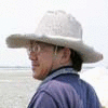
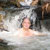
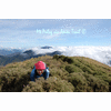
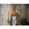
| Some time ago, surfing Google Earth, I had noticed an interesting region in the northern part of Terengganu. A horseshoe shaped mountainous region surrounds the Besut river. See the first image. A dead end road, starting from Jerteh, is the only way of access. There is one well-known waterfall, the Tembakah fall. And there might be more, probably only known to the locals. We decided to do a recce in the Ulu Besut region. Quite far from KL, so we made it a 4D3N trip and we also wanted to visit a few waterfalls in Kelantan on our way. Our first target was the Pelangi waterfall just after Gua Musang. A typical example of a failed project. Money has been spent to widen and tar the access road, build shelters, toilets, make a nice signboard. But no budget for maintenance and repair! Everything is in ruins now. After a long day we arrived in Jerteh, where we got a bit worried because there were no signs for the La Hot Spring resort, where we were planning to stay overnight. Another failed project? But no, the resort was there, with nice chalets for RM 55. New chalets were under construction. On the other hand, the hot spring baths had fallen in disrepair. Fortunately there were two nice pools, directly connected to the hot water source. We were the only guests, for dinner we had basic food in the restaurant. Not a place for culinary delights..:-) The next morning we drove until the end of the road at Kg Keruak, where we had coffee at a roadside stall. We were lucky. Asking about waterfalls, a man told us that there was one, but not easy to go there without a guide. So we arranged a guide, who arrived a little later, with his gun! First we had to drive though palm oil plantations, then into the jungle. Just possible for my Kembara. Where the road ended, we started walking for about one hour along a clear trail until we could hear the sound of falling water deep in the ravine. Scrambling down, we reached a beautiful fall. After enjoying the view and taking a bath, we climbed up again to the trail and continued for another hour to the next fall. Scrambling down was very difficult here, but we managed to reach the river bed. The fall was just around the corner, about 100 meter away. Through a misunderstanding we did not have a look, but climbed up again at the other side of the river, to a logging road. So this tall waterfall we have seen through the foliage, but no pictures..:-( It became clear that our guide had visited these falls about twenty years ago, and that he was not sure himself about the right approach...:-) But it was a nice guy, he showed us elephant footprints and dung, and we also saw prints of a badak, a rhinoceros. I found it difficult to believe him, but he was very firm, from his description it must have been the Sumatran Rhino. A very rewarding day. The next day we left the Besut region, saw a powerful waterfall from far away, a target for a next visit. We drove back via Jeli to Dabong, visiting two waterfalls, Renyok and Chener and passing Stong. The tallest waterfall of Peninsular Malaysia, and I have never been there yet! We stayed overnight in the Kuala Lipis Resthouse, the former Residence. Kuala Lipis was the capital of Pahang state until 1955, and has a rich colonial architecture.One of my favourite towns. On the last day we visited the nearby Bama cave, before we sent Rahim to his kampong, where I collected the blowpipe I had ordered during my last visit. Finally we had ice cream at Kow Po in Bentong. A nice, rewarding trip, full of variety. | ||||||||||||||||||||||||||||||||||||||||||||||||||||||||||||||||
| ||||||||||||||||||||||||||||||||||||||||||||||||||||||||||||||||
| ||||||||||||||||||||||||||||||||||||||||||||||||||||||||||||||||
|