The DART mission

Two years ago I published a detailed blog post: Will an asteroid hit Earth? In that post I discussed the scenario that an asteroid had been discovered on a collision course with Earth and what could be done to avoid such a possibly catastrophic collision. One option is to send a spacecraft to the asteroid and let it crash with it. The impact should change the course of the asteroid, so it would no longer hit Earth.. The DART mission will test the feasibility of this “kinetic impactor” technique. DART will be launched on 24 November, so it is time for an update.

The acronym DART stands for Double Asteroid Redirection Test. Target for DART is the minor asteroid Didymos, discovered in 1996. It has a diameter of 780 meter and orbits the sun in 2.11 year. In 2003 it was discovered that Didymos has a small moon with a diameter of 160 meter. This moon has been named Dimorphos , it orbits Didymos in about 12 hour at a distance of 1.2 km. DART will crash into this moon at a speed of 6.6 km/s. and change its orbit slightly. In the infographic this change is hugely exaggerated. It is estimated that the crash will change the speed of Dimorphos only about 0,4 mm/s and its orbital period about 10 minutes

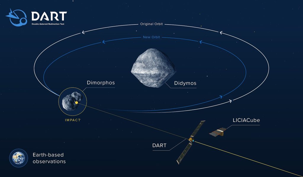
Originally DART was part of the much more ambitious AIDA mission. The crash will take place at about 11 million km from Earth. How to observe the effects of the crash? The solution was to launch another spacecraft earlier than DART, which would reach Didymus and go into orbit around the asteroid. This AIM spacecraft , to be developed by the European Space Agency (ESA), would observe the crash and send data back to Earth. It would even deploy a small lander, MASCOT2 to study the properties of Dimorphos.

But in December 2016, AIM was cancelled by ESA, after Germany withdrew the 60 million Euro funding for the project. I commented in the above mentioned blog:

As an European I feel rather ashamed that Europe has acted this way.

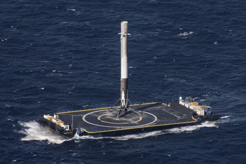
NASA decided to continue with DART., which will be launched by a SpaceX Falcon 9 rocket. A fascinating feature from the Falcon 9 is that part of it (the first stage) will return to Earth, land vertically (!) and can be used again for other missions. It will land on a so-called drone ship, an unmanned platform in the ocean. There are three of these drone ships active at the moment, all with poetic names. The Falcon 9 will land on “Of Course I Still Love You” Here is the ship.

And here is a video of the take off and landing. You must see it to believe it ;-).

DART will arrive at the asteroid end of September 2022. The spacecraft will use autonomous navigation to point itself to the moon. It has a camera on board, the DRACO that takes high-resolution photos. On-board software will analyse these photos, be able to distinguish between Dimorphos and Didymos and point Dart to Dimorphos.

About 10 days before reaching its destination, DART will deploy a tiny spacecraft, a so-called CubeSat . This LICIACube has been developed by ASI, the Italian Space Agency and will take pictures of the crash. So at least images of the collision will be sent to Earth.

Here is a short YouTube video of the DART mission. I will point out a few details.

  • 0:07 The nose cone of the Falcon 9 opens to deploy DART
  • 0:15 the solar arrays are unrolled, a new technique. Each one is 8,5 m ;long
  • 0:22 The lens cover of DRACO opens
  • 0:26 Didymos in the center, Dimorphos to the right
  • 0:32 The orbits of Earth and Didymos. They comes close, but are still 11 million km away from each other when DART crashes.
  • 0:37 The Xenon thruster will steer the spacecraft
  • 0:41 The LICIACube is deployed
  • 0:54 DRACO will find the target
  • 0:58 Found the target
  • 1:02 On collision course
  • 1:04 The end of DART

My next update about DART will probably be in October next year.

Our new penthouse

In October 2005 Aric and I moved from Goodyear Court 7 in USJ to Perdana View in Damansara Perdana. We love the location and are happy with our condo, although it is a bit on the small side. The top floor of Perdana View has 2-storey penthouses and years ago we had a look at one of them. It didn’t appeal to us, just 2 units on top of each other.

End of August Aric accidentally noticed that a penthouse in our condo was for sale , which was considerably larger than the other ones. We contacted the agent, and had a look on1 September. I fell in love with the condo at first sight and convinced Aric that we should try to buy it. Here is a photo of Perdana View.

And here is an enlarged detail. At the right side I have marked in red the contours of our present condo. In the center the contours of the penthouse. also in red.

In this floor plan you can see how big the penthouse is (in red) compared with the other seven penthouses (in green)

On 3 September we paid a deposit for the penthouse, I could not buy it in my own name, but I could finance it. Here I am handing over the deposit cheque to the agent. In the background the present owner is watching.

Buying a property in Malaysia is a bit complicated, both the buyer and the vendor are represented by lawyers. Here Aric is signing the Sales & Purchase Agreement (SPA) at our lawyer’s office. That was on 22 September.

On 3 November our lawyer told us that all formalities were complete, so we could finalise the payment. On 5 November I went to the bank to write a cheque. There they told me that I could not directly transfer the money to the lawyer of the vendor, because I would not become the owner of the property! They said that they would call me the following week. I didn’t sleep well that weekend! On Monday they called me and told me that the solution was to first transfer the money to Aric’s account. He could then write the cheque to the lawyer. And that’s what we did. A huge relief. Here we are in our car just before handing over the cheque to our lawyer.

That evening we celebrated already a bit. Aric holding the SPA in his hand. Now we just had to wait for the keys.

Officially after payment you must receive the keys within five working days. And that’s what happened. This afternoon we got a call from our lawyer that we could collect the keys. No formalities. we didn’t even leave our car, a secretary handed over the keys and some documents.

We drove home and of course we immediately went to what was now OUR penthouse. I will show many pictures to give an impression. One of the attractions of this penthouse is that it has a roof garden.

We bought a few items from the owner, for example the dining table and chairs.

On the ground floor there is one big room which will become Aric’s room.

The owner presented us with a wine chiller! . The kitchen has everything we need, microwave, induction stove, fridge.

There is a spacious outdoor kitchen with a washing machine and dryer.

There is even a maid’s room. We will probably use it as a store room. And of course there is a toilet.

Strairs lead to the upper floor, which has a second living room and three rooms . One of them will become the guest room, with its own bathroom.

The upstairs living room.

The master bedroom, with a separate wardrobe and a state of the art bathroom

This will become my room. Enough space for my books. I bought the desk from the former owner.

The view from our penthouse. The bungalows are part of the Orang Asli village.

We went back later to see how the rooms looked with the lights on

It is now just after midnight here. I wanted to publish this blog before I go to sleep.

Topo Maps and Taiping

I love topographic maps. For my hiking trips I have bought a few from JUPEM, ,the Malaysian Survey Department. These are modern topo maps, scale 1:50000. Here is an example, a small part of sheet 126, the Hulu Langat Map, printed in 1994. I have marked some of my hikes in red and a few waterfalls in blue.

Probably JUPEM will have an archive of old topo maps, but there is nothing online. Actually I was unable to find any Malaysian site with historic map material.

Surprisingly the National Archive of Singapore has quite a lot of historic map material about the F.M.S and Malaya. I was very excited when I found a detailed map of Taiping, printed in 1928. It consists of four sheets, with Taiping in the center.

The scale of these maps is 4 Chains to an Inch. I had to Google to find the meaning of this colonial expression! A chain is a measuring device for surveying, with a length of 22 yards = 22 x 3 = 66 foot = 66 x 12 = 792 inches. Therefore 4 chains equals 4 x 792 = 3168 inches and the scale of the map in modern notation is 1:3168.

To create the map of Taiping town, I had to “glue’ the four map corners digitally together. Here is the result, not 100% accurate, but acceptable. I have used parts of this map in an earlier blog Meeting of Old-Timers . .

Recently a waterfall friend told me that he had found topo maps of Malaya in the National Library of Australia! A total of 379 maps, printed in the 1940s. Below I show two map details, the actual survey data go back to 1913. Notice the scale, one inch to a mile, 1:63360 in modern notation, 20 times the scale of the Taiping town map. The second detail explains why these maps are in the Australian National Library. Australian soldiers were fighting in Malaya against the Japanese and later against the communists during the Emergency.

The maps are very detailed with an extensive legend.

Here is the same part of the Ulu Langat map as above. If you enlarge the two maps and compare them carefully, you will see that the two waterfalls in Sg Ampang are indicated in the 1940 map (and a few more, smaller ones). To be honest, I doubt if those numerous small tributaries in the old map have been really surveyed.

It is a real treasure trove of information. But mow back to Taiping! Here are the two maps, containing Taiping, images 94 and 96 in the NLA collection.

Again Taiping is on the side of the map, so I had to “glue” the two maps together. Here is the result. Notice how Taiping is bordered on the West side by dredging locations, North Taiping dredging, Asam Kunbang dredging and South Taiping dredging

Here is a detail with the Port Weld Railway. Two stations between Port Weld and Taiping: Matang Road Halt and Simpang Halt. Port Weld had a Police station (PS), a Post & Telegraph Office (PTO) , a Customs station (CS) and a Forest checking station (FCS) . Teluk Kertang is where Isabella Bird landed in 1879. It still had a Customs station and a Forest checking station.

And here is a detail with the winding road up Maxwell Hill, ending at the Cottage. A few of the bungalows are marked, the Nest and the Box. Birch hill, Caulfield’s hill and Gunung Hijau are marked. There is a Post & Telegraph office at the 6th mile. And, a surprise for me, a hill near the Lake Gardens (lower left corner of the map) is called Speedy’s hill. For comparison I have also taken a GE screenshot of the same region.

The NLA topo map collection has often several editions of a specific map. The Taiping map is available in a 2nd edition, printed in September 1943 and a third edition, printed in May 1945. I noticed only one interesting difference, the access road to the Taiping Aerodrome. See the two screenshots. The third edition has a note : With additions and corrections from intelligence operations .In that period Malaya was still occupied by the Japanese!

Here is a Google Earth screenshot of the same region. To make comparison easier I have marked the old access road in red. I have also indicated Aulong, a New Village, built during the Emergency. Notice the many lakes in the upper left, remains of past dredging activity.

When you find other interesting features in these maps, you are welcome to write a comment.