
One year ago I wrote a post about the Paleomap Project. At the end of that post I included a link to the Story of the Malay Peninsula. Here it is again. The clip is less than 3 minutes and worth watching.
I ended my post with: Notice how during the Ice Ages the sea-level was so low that the islands of the Malay archipelago were connected. This was called Sundaland. Topic for another post.
Here is my post about Sundaland.
What is actually an Ice Age?
Probably most people will first think about the funny Ice Age movies, but hopefully many will also know that there has actually been a period in Earth’s history, where the climate was cold and a large part of the Earth (North America, Europe) was covered with ice. That was about 21 thousand years ago and it is commonly called the Ice Age. Here is a Paleomap of Earth during that time.
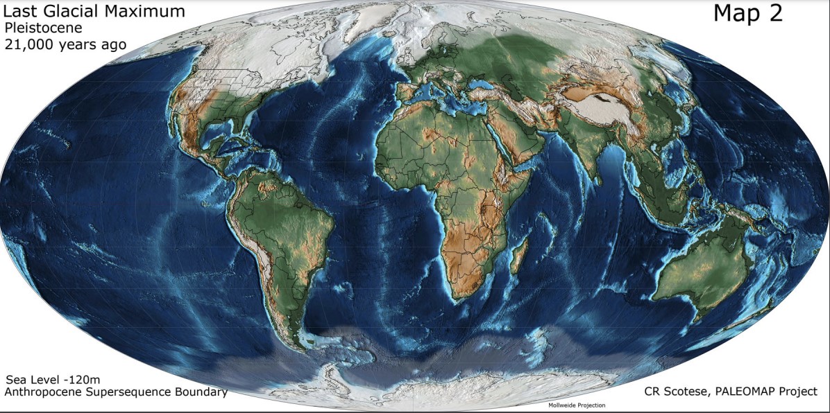
Notice that the map doesn’t say Ice Age, but Last Glacial Maximum ! I got interested, Googled a lot and wrote a separate post Ice Ages. Here is a summary.
- In the 4.5 billion years of its existence, Earth has been mostly (~85%) a Greenhouse, no icecaps, icesheets, glaciers. But there have also been at least five major periods that Earth was an Icehouse, partially covered with ice. These Icehouse periods are called Ice Ages. At this time Earth is in the Late Cenozoic Ice Age, which started 34 million years ago.
- In an Ice Age there is always permanent ice, but the amount fluctuates. There are periods that the ice advances, they are called glacials. And there are periods that the ice retracts, called interglacials.
- The last glacial was about 21.000 years ago and is often called the (Last) Ice Age. At the moment we are living in an interglacial, icecaps, icesheets, glaciers are retracting. But Earth is still an Icehouse.
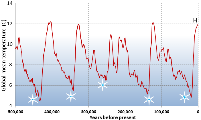
There have been numerous glacials and interglacials in those 34 million years. Here the global temperatures for the latest are shown. Notice that the timescale is from right to left, so the last glacial (“the Ice Age”) is the rightmost snowflake. And there is an obvious regularity with a period of roughly 100.000 year. If you want to know more about the theory, read the Milankovitch Cycles article in Wikipedia.
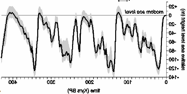
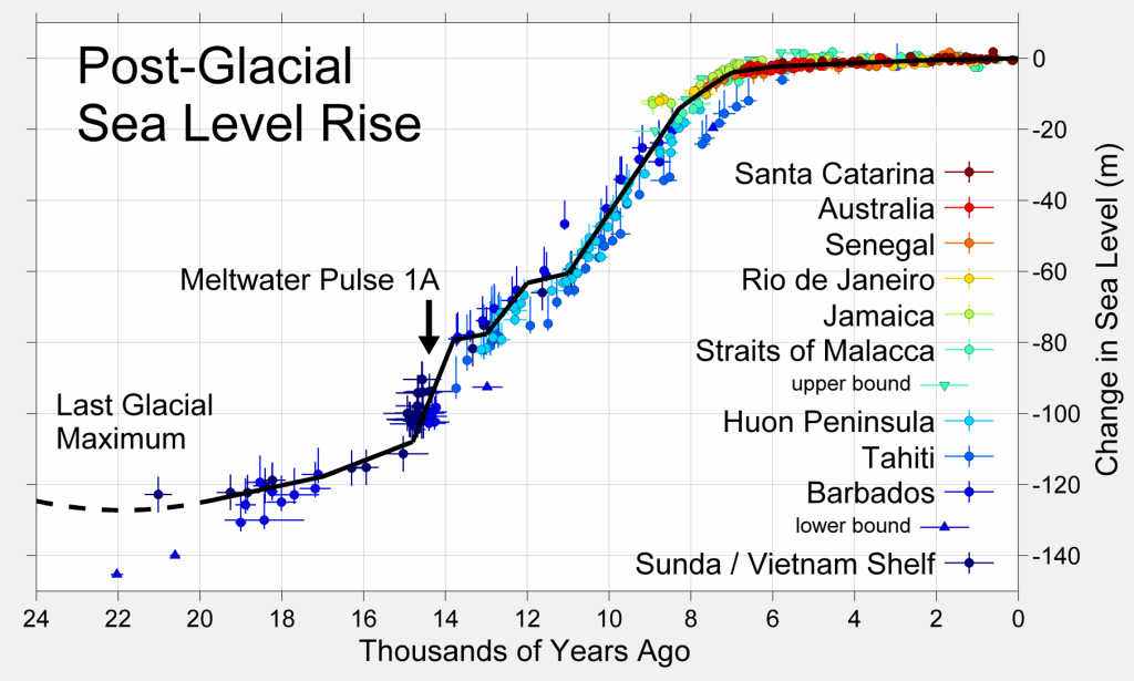
In this blog we are especially interested in sea levels. During a glacial a lot of water is frozen in icecaps, icesheets and glaciers, so the sea level drops, and during an interglacial ice melts and the sea level rises. Here are the sea levels during the last 400.000 years. In the original graph time goes from left to right, I have flipped it to make comparison with the temperature graph easier. Notice the similarity between temperature and sea level. During interglacials sea levels were about the same as nowadays, but during glacials they were up to 120 meter lower.
I will now concentrate on the last 150 thousand years, Here is a more detailed temperature graph. Starting from the left, we see the end of the Penultimate Glacial at about 135 thousand year ago. It was a very cold one. Then, relatively quite fast, temperatures are rising, until they reach a maximum at 125 thousands year ago in the Eemian Interglacial. Warmer than nowadays, sea level 6-9 meter higher (!) than today. After this maximum, slowly and irregularly , temperatures are dropping, until a new glacial maximum is reached, about 21 thousand years ago. After this the temperature rises again and we reach the Holocene interglacial in which we are living nowadays.
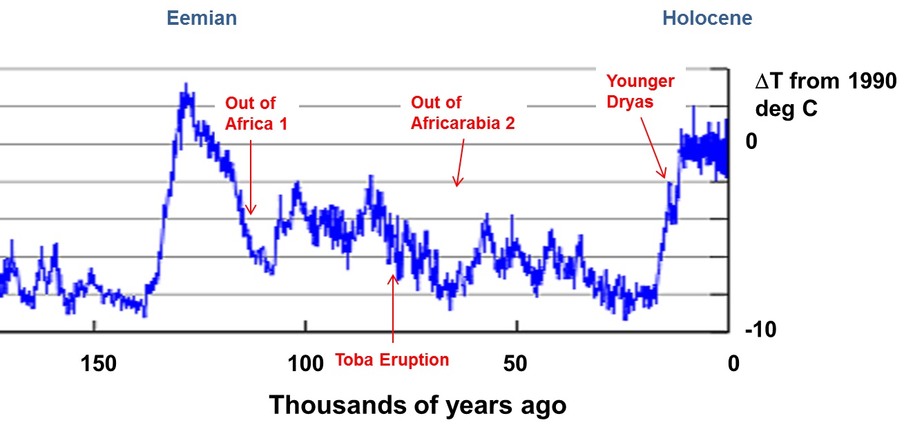
This time period is very interesting for homo sapiens. Indicated are two waves of migration out of Africa. And about 74.000 year ago the Toba volcano on Sumatra erupted, one of the largest eruptions in Earth’s history. Present day Lake Toba is occupying the caldera of this eruption. There is a theory that this eruption almost caused the extinction of homo sapiens, but this Toba catastrophe theory is something for a separate blog.
We zoom in one more time and look at the sea level. It was 120 m below present during the last glacial maximum, then rising more or less gradually until it reached present levels around 6000 years ago. Around 12-14 thousand years ago, there was an interruption with a cold period (Younger Dryas). Also notice the steep increase around 14 thousand years ago, caused my melting icesheets , about 5 cm per year !
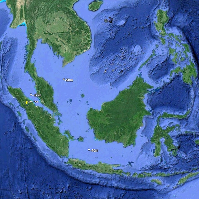
A sea level rise of 120 meter is enormous. Here is a Google Earth screenshot of South East Asia. The color of the sea indicates how deep it is, light blue is shallow, dark blue deep. When you open Google Earth on your computer and move your cursor over the screen, the depth is indicated. I have done that for three locations, and found 50, 30 and 40 meter.
When the sea level drops 120 m, the whole light blue region would become land!
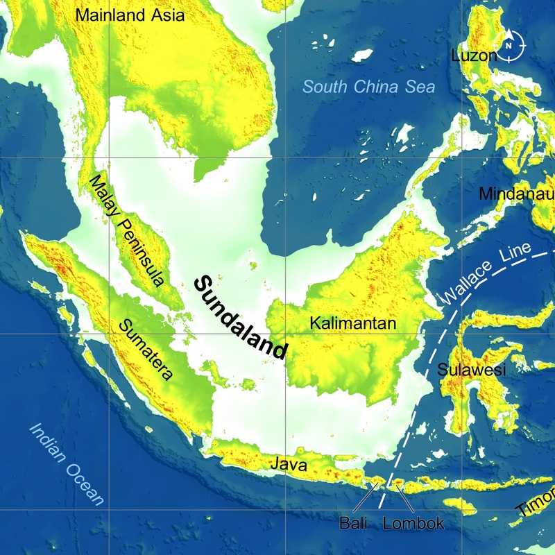
Here is how the region would look like, 21 thousand year ago. Sundaland! A continental shelf, exposed when the sea level is low. If there had been public transport in those days, you could have traveled overland between Indonesia, Malaysia, Thailand, Cambodia en Vietnam! And in the far future, during the next glacial, that will be possible again 😉 .
Here is a video, where you can follow Sundaland from the last Ice Age until present. Only 44 seconds, worth watching. Created by Dhani Irwanto, more about him later.
There are more regions on Earth where something similar has happened. In the lower right part of the video, you can see part of the Sahul shelf. During the last Ice Age Australia and New Guinea were connected.
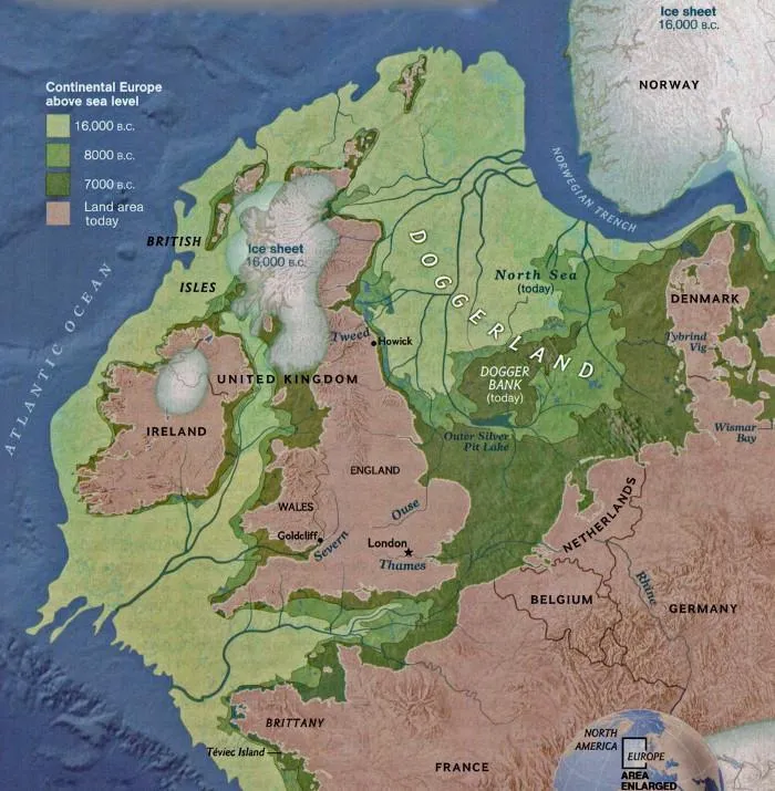
And in Europe during the last Ice Age, England, Ireland and mainland Europe were connected. The continental shelf is called Doggerland. Around 6500 year ago England became an island (again).
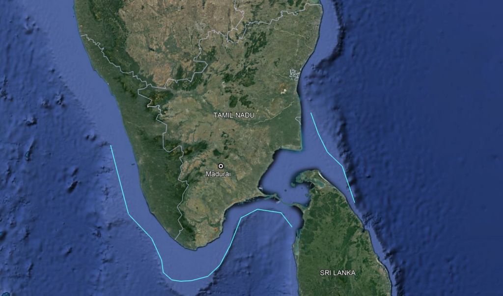
One more example. During the last Ice Age Tamil Nadu and Sri Lanka were connected. In this Google Earth image I have roughly marked the contour line (isobath) of 120 m below sea level. Some land is now submerged but not a continent as some Tamil nationalists still believe. See my blog Kumari Kandam & Lemuria.
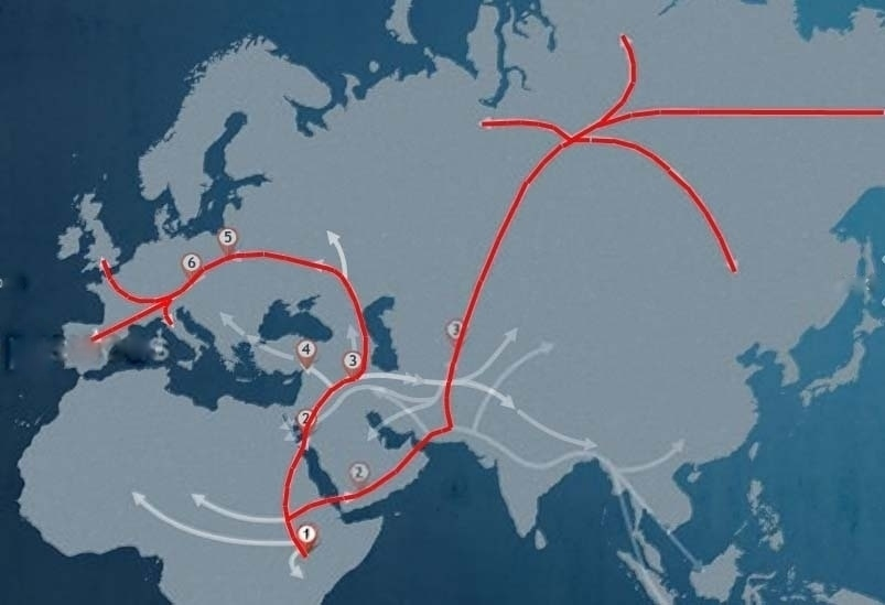
Sundaland is a huge landmass (~ 1.8 million km2), now partially submerged. but large during the time that homo sapiens migrated out of Africa. Here are some of these Early Human Migration routes.
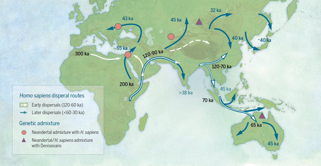
1in 2012 Aric and I took part in the Genographic Project , we sent samples of our DNA and got it analysed. It resulted in this map with the routes followed by our (maternal) ancestors. Read my blog My Ancestors for more details.
As you see there are migration routes to South East Asia and Sundaland. Could it be that during this last glacial there was a civilisation in Sundaland, later destroyed by the rising sea levels? Could that have been the lost continent, Plato’s Atlantis? Or the Garden of Eden?
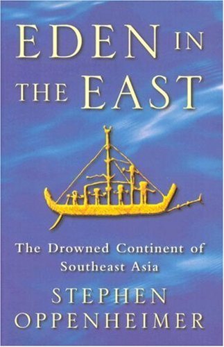
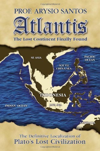
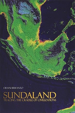
In the last few decades, three books have been published advocating exactly that. In 1999 Stephen Oppenheimer published Eden in the East. According to him it was Sundaland where the first human civilisation started. After Sundaland became flooded (Noah’s flood!), the population dispersed and fertilized the cultures of Mesopotamia, Egypt, China and India. A few years later, in 2005, Arysio Santos published Atlantis, the lost continent finally found. Santos was convinced that Sundaland was the Garden of Eden and Plato’s Atlantis. Quite recently, in 2019, Dhani Irwanto published Sundaland: Tracing The Cradle of Civilizations. Same approach. All these books are still for sale at Amazon.
It’s a fascinating topic, and there is no doubt that Sundaland existed. But Atlantis, the Garden of Eden, the Cradle of Civilisation? Here is some information about the authors.
- Stephen Oppenheimer (1947-) is a British paediatrician and geneticist. After 1997 he started a new career as a researcher and popular-science writer on human prehistory.
- Arysio Santos (1937-2005) was a Brazilian nuclear engineer, but “his true hobby in life was researching arcane subjects such as Symbolism, Alchemy, the Holy Grail, Comparative Mythology and Religion” (quote from his own website)
- Dhani Irwanto (1962 -) is an Indonesian hydro civil engineer. Founder of Indonesia Hydro Consult in 2010 and its director until now. Became interested in Sundaland and has written books about it.
The authors have in common they have no formal training in the subject matter. They were captivated by the subject and delved into all aspects of it, climatology, geology, linguistics, anthropology etc. Their approach, especially Irwanto’s, tries to be scientific. But it is still Fringe Science, outside the mainstream discipline.
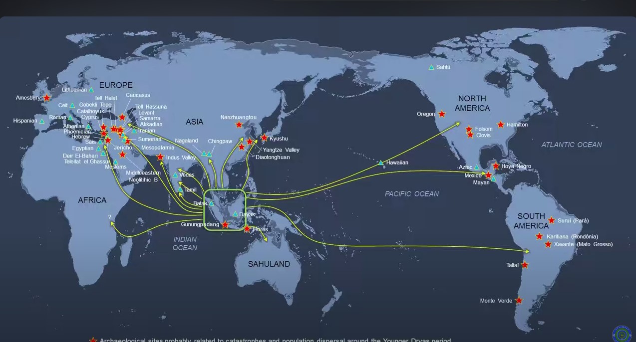
I was considering to buy Irwanto’s book, but then I discovered a video Tracing the Cradle of Civilisations in Sundaland, about a lecture he gave in the Philippines in 2017 at an Asean Advanced Archaeology Symposium. Brilliant presentation, worth watching (28 minutes).
But he is really going too far in his enthusiasm. Here is a screenshot from the video. Everything, all over the world , originated in Sundaland. So I may not buy the book.
Wow, that is such a detailed post. You’ve certainly done a lot of work. I’ve always been interested in the Wallace Line. Especially when I went to Maluku and saw some of the animals which are not seen in other parts of SE Asia.
Yes, and Wallace didn’t know yet about continental drift and tectonic plates 😉 !
Hi Jan, some years ago at a geological society of Malaysia meeting I proposed from my research that 90 Ma, KL was sitting over a mantel plume where Toba sits now, also I also proposed that if you looked out over KL from the TV tower restaurant the surrounding country was similar in features to many know impact craters. My reasoning being that a lot of the tin and other minerals found within the surrounding could be the result of shock metamorphism. It has been proposed by other that the Toba Flume was the result of an Impact. Well there is something for you to think about..
Take care
Robert (a Noble Brit) LOL
Interesting reading is a book called Noah’s Flood by William Ryan & Walter Pitman. Which explains a lot about the forming of the Black sea some 5600 years ago and the effect it had on movement of peoples within the area.
Cheers
Robert
Wow. Thanks for this Jan
So much to think about.
An amazing blog