| Following Chapman's footprints, 9-1-2010 |
In September 1943, Spencer Chapman (The Jungle is Neutral) is staying in the region of Bentong, when he gets an urgent request to go to the guerrilla headquarters in Perak. He is suffering from fever and it becomes a very tough journey. From Bentong he follows the Sg Repas, crosses the main range and then goes down the Sg Luit to a camp near old Kuala Kubu.
Sg Luit? I knew that river, you have to cross it on the way to Bukit Kutu. It might be interesting to explore this river and find out how far we could go upstream. My friend Keong was eager to join. He knew that there was a good trail quite far in, because he had been camping there recently.
When we arrived at Kg Pertak we noticed that they had been upgrading the road until the first river crossing. Hopefully they are not going to "develop" the place. After crossing the Sg Luit over a ramshackle bridge, we left the Kutu trail and followed a clear trail on the right bank of the river. It must have been a former logging road, there were signs that it was still being used. We passed two attractive small waterfalls and after about 1.5 hour reached the spot where Keong had been camping before. We continued hiking and after one more hour found an attractive place for lunch.
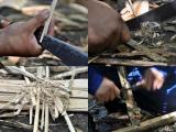
Here Keong, who is very interested in bushcraft, wanted to try one more time to make fire using the "fire saw" method. He did his utmost best, it looked impressive, but finally he had to fall back on the fire striker method. In the meantime I had already prepared coffee, using my Camping Gaz and a lighter... hehe.
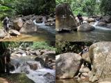
Although the trail continued, we decided to go back and Keong suggested, shall we trek down the river? Why not, I replied. And so we did. Big fun, but of course the going was slow, it took us 2.5 hours to reach the camp (see GE pic, river trekking is in blue). There is another small fall there and it was pure bliss to take a bath...:-)
I have a gut feeling that this time we really HAVE followed Chapman's trail. And I have a hunch that when you continue this trail, it will finally cross the main range and go down the Repas river to Bentong. BUT.... you will have to climb until an altitude of more than 1200 m! See the Google Maps picture.
Any takers? I will pass ...:-)
|
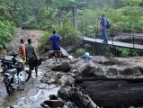 First river crossing (Sg Lar)
|
 Good trail
|
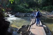 The crossing of Sg Luit
|
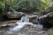 First fall
|
 Second fall
|
 A strange spider
|
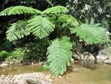 Huge ferns
|
 Another spider (missing a leg)
1 comment |
 Better avoid this stream after a downpour.
|
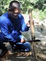 Keong prepapring the bamboo
|
 Preparations
|
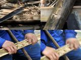 The fire saw method
1 comment |
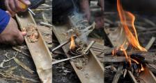 Using the flint is easier!
|
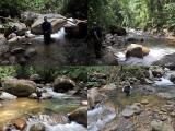 River trekking
|
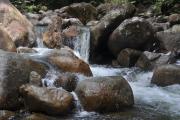 Nice cascades
|
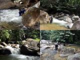 More river trekking
|
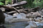
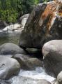 Huge boulders
|
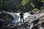
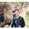
 Kwai Loh in action
1 comment |
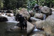 Big fun but tiring
|
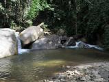 A small fall near the camp
1 comment |
 Heavenly bliss..:-)
1 comment |
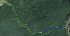 Our trek on Google Earth
|
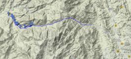 Chapman's route
1 comment |
|
 |
wrote on Jan 12, 2010:
Total distance is how far and total time of trekking? |
|
 |
Kwai Loh wrote on Jan 12, 2010:
From the end of the road until our endpoint about 5.5 km in ~ 2.5 h. That is of course only a small part of Chapman's route |
|
|
wrote on Jan 12, 2010:
Yan, I will try to hike chapman's trail in near future. |
|
|
wrote on Jan 12, 2010:
Man from the water..... |
|
|
wrote on Jan 12, 2010:
Delta Force guy haha |
|
 |
wrote on Jan 15, 2010:
I'd have used Camping Gaz and a lighter too. :)) |
|
 |
wrote on Feb 1, 2010:
that looks like the golden orb-web spider |
|
|
wrote on Feb 1, 2010:
very beautiful pool :) |
|
|
 |
You are welcome to comment, but you must register and/or
login first.
|
|


